How it's done
The following project phases are performed as an iterative process to implement GIS. Each phase refers back to, and modifies previous phases until a satisfactory end result is achieved. Depending on the scope (size and kind) and intended functions of the GIS, these phases may be more or less time- and detail-intensive. For example, choosing a Minimal Option (bottom of Services page) does not necessarily require a full program definition but does require decisions about what data is on-hand, what data is needed, who is to perform the work and where, and what details (attributes) are to be contained within datasets - more like a standard statement of work.
Even for non-municipal GIS implementation, planning is necessary so that you can reap the best return on investment.
Phase 1) Project planning
Project planning identifies the scope and intended purpose(s) (mission statement) of the GIS system. Goals and desired outcomes are identified along with potential barriers to implementation. Consent and buy-in of all primary stakeholders is essential to ensure that (a) GIS investment is nurtured and preserved and (b) maximum benefit is realized. From a very general perspective, stakeholders include decision makers (board/council), managers, workers/staff, and constituents/customers.
Phase 2) Assessment
The assessment identifies existing data and resources (computers, software, staff, budget) and describes needed data or resources.
Phase 3) Design the overall GIS program
The design phase builds upon information in the Assessment, Phase 2, and is guided by the Goals and Scope documented in Phase 1. Design specifics include decisions about recommendations presented in the Assessment and remaining work to be completed through data handling. During the design process, datasets and associated details are sketched as diagrams and tables to be certain that the data will serve the intended purposes. Tables provide specific attribute details and when databases are to be constructed, tables include comprehensive choice lists to preserve database integrity and reliability.
Enterprise systems include decisions as to level of functionality, connectivity for all users, physical placement of servers within existing architecture, and cyber security.
Phase 4) Acquisition and development
This phase summarizes existing resources and outlines the next steps involved in carrying out Phase 3 Design decisions and implementation specifications. More specifically, Acquisition includes rounding up available data, creating new data as needed according to the applicable design decisions, and physical computer components like servers and workstations.
Phase 5) Operation and maintenance
This phase schedules initial implementation for testing and documents specific roles for staff and management as well as specific considerations for maintaining the GIS into the future. Geographic Information Systems are dynamic and require steady maintenance to ensure adequate return on investment.
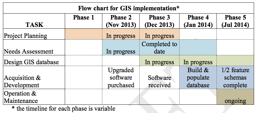
The chart below provides a sample timeline of how the iterative process might play out for geodatabase implementation:


